

&Conote Drone
At Chubu Electric Power Grid Co., we offer a consulting service called '&Conote' to work together with our customers to solve challenges related to their electrical equipment. The drone inspection service, a part of the &Conote menu, enables high-precision imaging with automatic flying technology, making it possible to conduct safe and efficient high-altitude inspections. Additionally, we utilize our years of experience in inspections and abnormality assessments to provide advice from the perspective of equipment owners. Please take a look at the technological capabilities of Chubu Electric Power Grid!
We are a manufacturer of wireless communication devices.
We are planning to Sample display of Image transmitting apparatus, radio control, telemetry, etc.
Feel free to stop by the TKKWorks's exhibition booth!


Tobaseru is a service that shows you on a map where you can fly your drone.
Tobaseru is a service that shows you on a map where you can fly your drone.
This application solves the problem that drone users often face: "There are no or few places to fly."
DroneShcool,Dronesoccer,Synerex
Operation of a large drone training facility run by Seino Drone Academy. National qualifications, industrial drone pilot qualifications, and schools. Operation of the Tokai Drone Soccer League. Sales of GNSS devices that track drone positioning information.
Development and support of various drone (unmanned aerial vehicle) school businesses.
As a drone training school, we offer the following courses: - Private qualification (multicopter, airplane) - National qualification (multicopter 1st class, 2nd class) *Recognized training organization by the Ministry of Land, Infrastructure, Transport and Tourism - Instructor training (private) - Support for launching new schools We conduct classes widely for general participants, corporate organizations, and more. We provide support for individuals, corporations, and organizations that want to start a new school (drone training school).
We will introduce our efforts to train drone engineers with the knowledge and skills required for drone development, production, customization, maintenance, etc., which are required by drone manufacturers and service providers.

Manufacturing of various prototype parts, production of jigs and fixtures, and other engineering services.
We are a company capable of designing and manufacturing prototype automotive parts and small-lot production items from start to finish at our own factory.
We use the technology we have cultivated in the manufacture of carbon parts for racing cars to produce high-quality carbon parts for drones.
We also provide design support for drone manufacturing and propose new lightweight technology.
We promote zero emissions in Japan, both on land and in the air.
Proprietary AI accelerates on-site work and simplifies infrastructure inspection work
Tohoku Drone develops proprietary, in‑house AI detection algorithms specialized for infrastructure inspection. The system extracts anomalies from imagery of public infrastructure assets in real time, delivering both efficiency and quality in inspections.
We have released a Simple Flight Checklist App that streamlines on‑site safety checks.
For drone adoption, our consulting services work alongside clients from development through successful operational adoption.
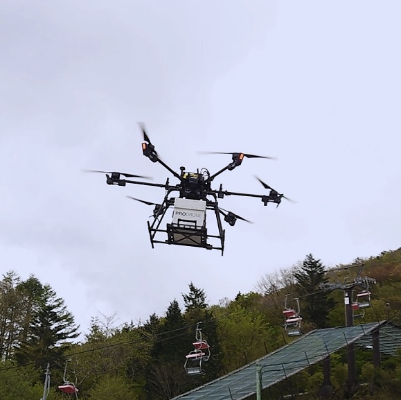
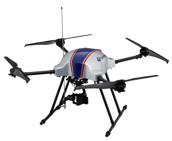
Drone flight testing
Toyone Village is located at the highest elevation in Aichi Prefecture, and among its attractions, Chausuyama Kogen is a popular spot blessed with the natural beauty of all four seasons, attracting many tourists. However, there have been challenges in transporting supplies to the summit area. To address this, Aichi Prefecture, Toyone Village, and Prodrone, a drone manufacturer based in Nagoya, have collaborated in a public-private partnership to develop a drone delivery system that transports meals from food stalls at the foot of the highlands to the summit of Chausuyama Kogen. This initiative aims to contribute to regional tourism revitalization and improved convenience, while also establishing a new logistics model utilizing the latest technology.